Issues by Water Year: 2011
Landslide
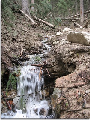
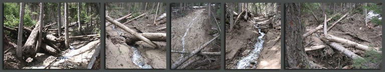
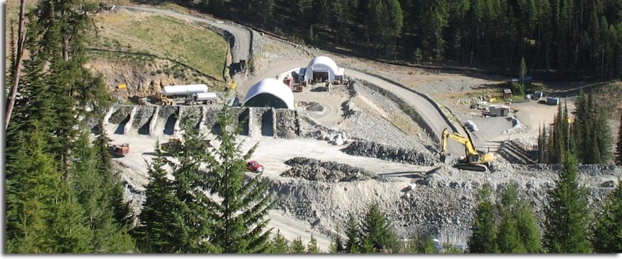
In May 2011, a large slope failure below the Buckhorn Mine sent a wall of mud and large trees flowing down Gold Bowl Creek. Just below the mine facilities and one of the treated mine water discharge areas, the side hill of Gold Bowl Creek gave way, sending mud cascading thousands of feet, uprooting large trees and scouring the creek drainage of all vegetation 12-15 feet high. Surface water monitoring site SW-9 was obliterated by the May 14, 2011 landslide. A replacement monitoring point was established at SW-9A.
According to Geology (Chernicoff & Whitney, 2002), blasting that accompanies mining, quarrying, and road construction can trigger mass movement. Vibration from these activities can force apart grains of loose sediment, eliminating the friction between them. Sometimes human activity, such as mining, may combine with natural factors to increase the chance of mass movement.
Crown/Kinross consultant Golder Associates performed a dye test to see if treated mine water discharged to the stormwater ponds DA 10/11 was connected to the massive mudslide that blew out the side hill of Gold Bowl Creek in May 2011, uprooting trees and scouring over half a mile of creek. In summary, the results showed that DA 10 contributed to flows in the slide area. OHA does not consider the DA 11 test conclusive because it occurred after the slide area had dried out. There was no flow by the time of the test. Ecology has curtailed treated mine water discharge to these locations.
The National Pollution Discharge Elimination System (NPDES) states, “Discharges must not cause erosion or slope instability.” Crown/Kinross went to great lengths to represent this spring’s mudslide as unrelated to the mining activity. However, as noted above, a connection was established.
As a result of landslides, two of the four treated water discharge points were restricted, and the company sought additional places to discharge treated mine water. Additional environmental review will be necessary to examine the impacts of discharging large quantities of treated water into yet unidentified locations, before the new discharge points can be permitted. It is in everyone’s best interest for new discharge points to be developed; otherwise, water builds up in the mine.
Water Quality Requirements Violated
- Concentrations of mine-related contaminants have been increasing in surface water and in groundwater since the mine operations began
- Water infiltrating through the PAG development rock has leached contaminants into Gold Bowl Creek
- Erosion from treated mine discharge has contributed to slope instability
- Other unpermitted mine discharge has entered surface water
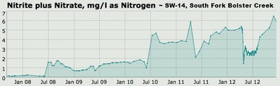
The increases in nitrate and chloride concentrations in SW-14 made it apparent that a preferential pathway exists between the mine area and upper South Fork Bolster Creek.
The mine has leaked contaminants since it began operations. The mine’s monitoring shows that the mine has failed to maintain a capture zone, which is supposed to keep mine contaminants out of surrounding ground and surface water. Recent water quality violations began with the spring thaw in May 2011, when a major mudslide erupted below one of the treated mine water discharge locations. The landslide released a 20 foot wall of mud, scouring the vegetation and ripping out trees for half a mile down Gold Bowl Creek.
During May and June, water quality in Gold Bowl Creek exceeded standards for nitrates from blasting and sulfates from acid generating rocks. Sulfide rock removed from the mine is stored on the surface, exposed to the elements and can form sulfuric acid. Nitrates from blasting have also been elevated in Bolster Creek, west of Buckhorn, and in groundwater wells east of the mine.
Unfortunately, discharges of pollutants have been occurring from the mine that are not permitted by the NPDES. In fact, the permit specifically states that no other discharges are permitted. However, contaminants from the mine and waste rock pile discharges have increased in ground and surface water, sometimes in excess of Water Quality Standards (WQS), and yet since April 2008, Ecology has not issued violations for failure to maintain the capture zone, nor for discharges from the waste rock pile. Throughout 2011, OHA continued to encourage Ecology to hold the company accountable for these non-permitted discharges.
Reporting Issues
As part of the response to the Department of Ecology’s Administrative Order #8820, Crown/Kinross updated the Groundwater flow model for the Buckhorn Mine. OHA reviewed the Nov. 2011 Golder report entitled, “Updated Groundwater Flow Model and Mine Inflow Estimates,” and provided comments to Ecology. OHA found the report to be lacking coverage of some critical issues, including omission of grouting to minimize groundwater inflow to the mine and a lack of numeric estimates of groundwater inflow to the mine.
Development Rock Reporting Needs Improvement
Water leaching through development (waste) rock piles, especially in the spring, has increased pollutants in ground and surface water. Kinross is required to submit a report to the Department of Ecology each quarter to provide an analysis of the past quarter’s development rock information.
Ecology rejected the 1st quarter report submitted in August and is requiring the company to generate a report based on criteria at that time.
Crown/Kinross made commitments at the March 15, 2011 Annual Meeting regarding reporting of development rock, including mapping faults and applying shotcrete. No information about faults was in the quarterly report, and shotcrete application was limited.
Contaminants travel through faults or other preferential pathways in the underground mine. Faults and voids in the cemented rock fill (CRF) are identified during mining. OHA had asked that these features be identified in the quarterly reporting to help track contaminant transport. OHA also suggested that increased shotcreting would increase groundwater protection. This suggestion comes as a result of failure of the capture zone, uncertainty related to seasonal fluctuations, and the unreliability of the groundwater flow model. OHA is concerned that the large backlog of PAG DRZ in the underground mine and the failures of the capture zone are degrading water quality around the mine.
OHA also recommended that ore headings should be analyzed for acid generating potential and if it is determined to be PAG, the area should be shotcreted before CRF is applied for ground control. Until this point, it appears that ore has not been tested to determine whether it is potentially acid generating (PAG)!
NPDES Permit Up for Renewal
In the midst of these serious issues, the National Pollution Discharge Elimination System (NPDES) permit came up for renewal. An administrative extension was granted. OHA maintained that at the very least, the NPDES renewal should increase reporting during the spring freshet so that discharges from the waste rock can be more thoroughly monitored. In 2011, one downstream well was monitored once a month, which is insufficient both in frequency and scope to ensure that water quality changes during freshet would be noticed. OHA also strongly suggested that any increase in contaminants beyond the background baseline levels should be highlighted and watched for increasing trends, and all water quality violations should be noted.