
Author:

Adaptive Management Plan, 2006

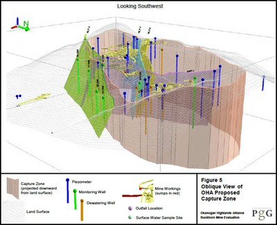
According to the mine’s original Adaptive Management Plan (AMP), the water quality problems at the mine should trigger specific actions. The steps are clearly outlined, requiring the company to: notify Ecology, identify the source of the contaminants and the extent of the plume, and develop a plan to remediate the problem. Over the years, various levels of investigation have provided useful data to help in the search for the contaminant flow path. Likely culprits have been identified, such as surface water from mine facilities, development rock stockpiles, and the underground mine workings. Collecting monitoring data in the appropriate locations, such as below the development rock stockpile, is critical to understanding the source of the water quality problems.

Phases of Adaptive Management

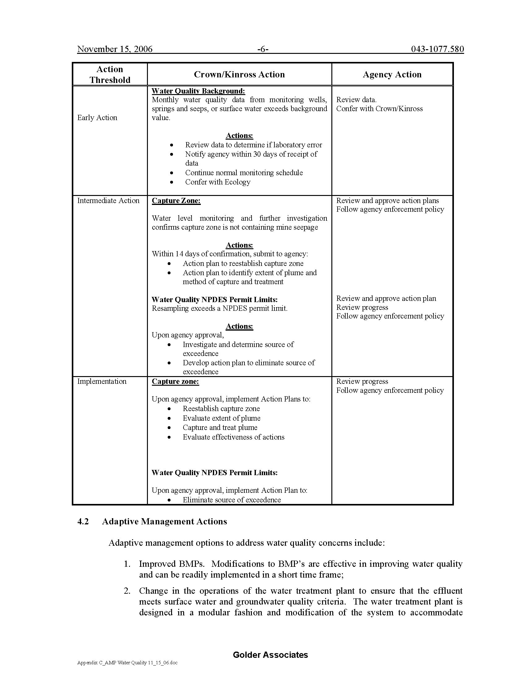
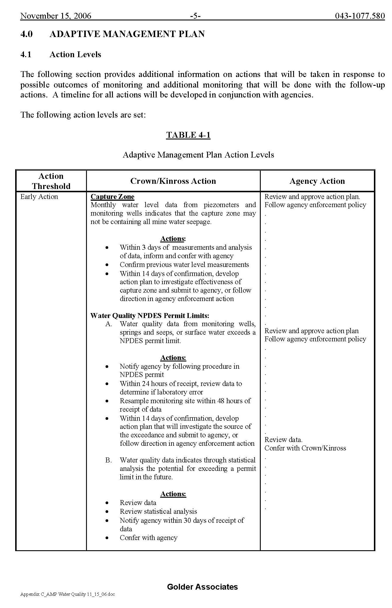
Adaptive Management details include an action threshold and indicate who would take what action. The specific plans have three phases:

  • Phase I (early action) based on 50% of predicted impact: Kinross would review data and determine the likelihood predicted impacts would be exceeded. If they think there would be a potential for greater impacts they would inform the agency in their annual report. Take voluntary action and continue monitoring. The agency would take no action.
  • Phase II (planning) based on 80% of predicted impact: If Kinross decides monitoring suggests impacts would exceed predictions, they would then develop a Contingency Plan. The agency would meet with Kinross and develop a plan.
  • Phase III based on 100% of predicted impact: Kinross would implement Contingency Plan. The agency would oversee contingency actions.

Below are examples from the Adaptive Management Plan, stating what actions will be taken if water quality data show parameters exceeding background values. Although levels have exceeded background since mining began, these adaptive management steps have not been followed.

AMP excerpt regarding water quality exceeding background levels (click to enlarge)
AMP excerpt regarding the capture zone (click to enlarge)
Ongoing AMP Issues
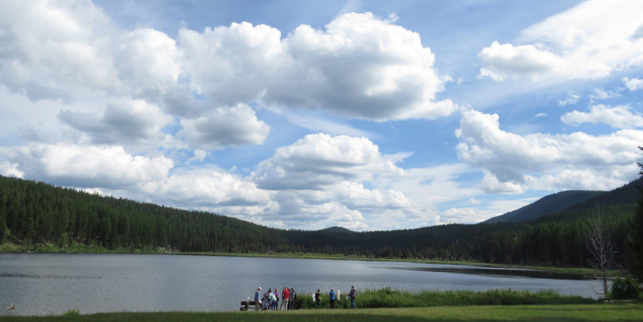
Kettle River Tailings Facility

There was a trend of increasing concentrations of nitrate, sulfate, and TDS in surface water; this should require Adaptive Management Plan action.

Issues with the Supplemental Environmental Impact Statement AMP

One of the major flaws in Ecology’s Supplemental Environmental Impact Statement (SEIS) was its reliance on adaptive management or more accurately a plan that is titled adaptive management but in reality has poor mechanism to adapt to changing situations. It would be more accurately be characterized as a monitoring plan. Adaptive management should be an active systematic process for continually improving management policies and practices by sequential learning from the outcomes of operational programs. It should be designed to experimentally compare selective policies or practices by evaluating alternative hypotheses. Ecology and Kinross want to redefine adaptive management and use it as a basis for the entire mine plan.

To put this plan in perspective, Ecology relied on this adaptive management plan for most aspects of the mine proposal including:

  • Dewatering impacts to seeps and springs
  • Dewatering and water supply impacts to steamflow
  • Fine sediment deposition and water quality changes to Marias Creek from the mine access road
  • Aquatic habitat improvements to mitigate for streamflow impacts from mine dewatering
  • Development rock management
  • Water treatment plant operations
  • Upland habitat protection, enhancement and management
  • Wildlife management along haul road
  • Kettle river tailings impoundment

The AMP was relied on to evaluate the monitoring data and compare it to what is predicted in the SEIS and to evaluate compliance to the requirements of various permits including:

  • The NPDES for the collection, treatment and discharge of mine water,
  • The water rights for the use of surface water and ground water supply and mitigation,
  • The construction and operational stormwater,
  • The hydraulic permit approval for the construction and maintenance new culverts and stream restoration,
  • The permits on National Forest Land,
  • The waste discharge and Dam Safety for the tailings impoundment

Water Rights for the Mine

Background

Water Rights were historically OHA’s main vehicle for protecting surface water. Ecology took the position that since Washington State Water Law requires that water be put to beneficial use in order to get a water right, that if water is not being put to beneficial use, a water right is not required. This absurd interpretation of water law created a loophole that allowed Kinross to dewater Buckhorn Mountain and dump the water.

OHA’s Initial Concerns in the Mine’s Planning:

The dewatering of Buckhorn Mountain would be the most damaging aspects of the proposed mine. Ecology approved for Kinross to extract all the water from Buckhorn Mountain’s heart of gold. In order to mine, people, fish, and wildlife would be deprived of clean water. In some creeks, clean water would be replaced with treated water that is supposed to meet minimum standards. In other creeks, no replacement is planned. Mine shafts would change the way water flows from Buckhorn Mountain, affecting people dependent on that water. It would take 15-40 years to refill the aquifer inside Buckhorn Mountain. During that time, the creeks, springs, and seeps critical for healthy fish and wildlife would be deprived of water.

Water Rights for the Buckhorn Mine proposal approved by Ecology:
  • G4-34904 (Mine Dewatering). This application approved November 21, 2007 for mining, industrial and flow augmentation for a maximum instantaneous beneficial use of 100 gpm with a total proposed annual withdrawal of 12.6 acre-feet per year, derived from groundwater associated with mine dewatering and operations. This water would be collected from sumps within the mine and from dewatering wells.
  • G4-34905 (Domestic). This application approved October 25, 2007 for dust control, mining, and domestic use for site employees from a single well for a groundwater withdrawal  with a proposed of 5 gpm and 5.2 acre-ft/yr.
  • S4-34999 (Storm Water). This application approved October 24, 2007 for a surface water diversion for industrial and mining use to augment mine operational needs not met by the quantities requested under Application No. G4-34905, for 50 gallons per minute (gpm) (0.111 cfs). This water would come from collection of storm water drainage from ore and development rock stockpiles.
  • R4-35093 (Reservoir). This application approved October 24, 2007 permits a storage facility (surge pond) for water derived from mine dewatering and storm water.
  • CG-CCV1-4P200 (Newman). This change application, approved on September 26, 2006, changes the purpose, place, and time of use of a certificated seasonal irrigation water right for two groundwater wells to use in year-round dust control and seasonal mitigation of mining impacts on stream flows. The total certificated quantities for this right are 300 gpm and 200 acre-ft/yr.
  • G4-35084 (Lost Creek Ranch). This application approved November 21, 2007 for instream flow mitigation for a maximum of 125 gpm from one well in the Myers Creek watershed.
  • CS4-ADJ47P45 (Leslie Trust). This change application approved October 19, 2007 changes an existing water right from agricultural use to instream flow mitigation use during mining and during recovery of water levels associated with cessation of mine dewatering. for up to 0.156 cfs and 29.9 acre-ft/yr. Use would revert back to agricultural at the end of mitigation.
  • CS4-ADJ47P36 (Thorp Trust). This change application approved October 19, 2007 is a permanent change in use from stock watering to instream flow mitigation for 3 gpm.
  • CG3-29653P (K2 Mining). This change application, approved on September 28, 2006, changes the place of use from the K2 Mine to the proposed backfill borrow site in Ferry County. The total permitted quantities for this Water Right Permit are 50 gpm and 80 acre-ft/yr.
Problems with the water rights Ecology issued:
  • There is an unreasonable level of uncertainty regarding the hydrogeologic modeling of the impacts of mine dewatering and the resulting streamflow depletion.
  • Baseflow calculations of streamflows are questionable.
  • Aquifer properties where stream flow reductions would take place are scarce. The modeling inputs are based on untested assumptions of aquifer behavior.
  • Ecology fails to consider the cumulative impacts of granting Kinross water rights on local water supply and downstream water resources.
  • Granting water rights to Kinross would be inconsistent with past actions by Ecology.
  • The mitigation offered by Kinross does not come close to offsetting the harm to senior water right users and the public interest.
  • The speculative nature of the mitigation proposed does not meet the requirements that new water rights not impair existing rights and that new rights not be detrimental to the public welfare.
  • The mitigation offered by Kinross is off-site and out-of-kind, primarily enhancement of downstream wetlands and streams instead of a long-term commitment to on-site restoration.
  • No reliable mitigation is being offered for stream depletion during the post-mining refilling of the Buckhorn aquifer.
  • There is too much uncertainty that the mitigation plan would adequately protect existing rights and instream flows from harm.

2008 Settlement Details

Below are details of the agreement from the April 2008 negotiations between OHA and Crown/Kinross, whereby an underground mine would proceed on Buckhorn Mountain with additional monitoring and stream augmentation.

Key Monitoring Provisions:

  • Crown/Kinross will hire an independent third party to do their monitoring and reporting.
  • Crown will provide funds for OHA to hire its own independent monitoring company to do annual audits, quarterly visits, and random sampling and testing to analyze Crown’s third-party work.
  • Crown will increase water quality monitoring on the west slope of Buckhorn Mountain.
  • Crown will increase monitoring for sediment during spring runoff.
  • Crown will lower the threshold for corrective action if sedimentation increases in Marias Creek.
  • Crown will collect baseline water quality and quantity data for residents’ wells that are reasonably close to the mine if residents have concerns. 
  • Crown will send OHA all monitoring data.
  • OHA will be permitted access to the mine site.
  • Crown and OHA will attend an annual meeting to discuss monitoring results.

Key Mitigation Provisions:

  • As long as they are operating the dewatering wells, Crown will run water over to the headwaters of Gold and Bolster creeks to maintain seasonal baseflow.
  • After closure of the mine Crown, will retire 25 acres of the Lost Creek Ranch irrigation water (15 acres more than the agencies required). This would add water to Myers Creek and Bolster alluvial fan groundwater to replace the predicted permanent reduction caused by mining.
  • Crown agreed to permanent conservation easements of their mitigation sites including the reclaimed mine site and opening them for public access.  
  • Crown will also fund a significant amount of additional mitigation sites throughout the area. 
  • Crown will fix problems with residents’ wells that are caused by mining activity.
  • Crown will make a good faith effort to minimize truck hauling on weekends.

3D Visualization, Pacific Groundwater Group

Pacific Groundwater Group created a 3D visualization video for OHA as part of and in support of OHA’s comments on the draft NPDES Permit renewal in 2013. It begins with a visualization of the Buckhorn Mine underground workings with relevant faults and monitoring wells. It transitions to show: first the 2006 FSEIS capture zone, then the expansion of the capture zone proposed in the Draft NPDES, and then OHA’s proposed capture zone as seen from the south looking north. OHA’s proposed capture zone consists of the Draft NPDES depiction in the north, south and west and with the 2006 FSEIS depicted on the east side. The visualization then transitions to a view looking southwest from northeast of Buckhorn Mountain, and repeats display of the same sequence of capture zones.

About the Project:

Visualizing how groundwater in Buckhorn Mountain interacts with the mine, geologic faults, and dewatering wells is coming closer to reality with OHA’s 3D Visualization Project, which will increase everyone’s understanding of how water moves underground. At this point, we have created a number of animations circling a transparent depiction of Buckhorn Mountain. The color-coded animations include various dewatering and monitoring wells and piezometers in cross sections of interest, with see-through portrayal of the company’s projected faults and underground mine workings. The groundwater levels at key seasons will be added to assist in an analysis of how the dewatering wells are influencing groundwater flow.

Over the years of the mine, OHA has made numerous recommendations to the company that they analyze the actual groundwater monitoring data instead of relying on predictive models, which have not been effective at predicting actual conditions. Early in 2013, OHA initiated a 3D mapping project, which developed into the 3D visualization. OHA is hopeful that this will give everyone another tool to analyze the monitoring data and hopefully see where the gaps are in understanding groundwater flow paths. The end goal is to stop contaminants from escaping the mine.

Analysis by Stratus Consulting, Nov. 2010

Analysis of Water Quality Impacts at the Buckhorn Mountain Mine and Recommendations for Improvement

This report (PDF, 1 MB) responds to contaminant increases that triggered adaptive management in Gold Bowl Creek. The increases are more extensive than previously reported. The report provides an overview of important events at the mine, violations and orders submitted by Ecology, information on water quality standards and exceedences that have occurred but were not noted by Kinross or Ecology, and adverse environmental effects that have occurred and their current status. The report proposes recommendations for actions that could be taken by Kinross to increase environmental protection.

The use of reverse osmosis improved the water treatment facility and lowered some contaminants downstream from the discharge points, but others related to blasting have been decreasing more slowly.

Matrix of Annual Reporting Requirements

Click here to view the full PDF (67 KB)

After the first year of mine operation, not only were there were some significant water quality challenges on Buckhorn, but the required annual reporting was incomplete, lacking basic foundational data needed to analyze the mine’s impacts and the accuracy of model predictions. To quantify the inadequacy of the reporting, OHA completed an extensive review of the mine plans and developed a comprehensive matrix of annual reporting requirements. Using this matrix, OHA assessed the degree to which the company satisfied the requirements for Water Year 2008 and presented the results to the Department of Ecology and Kinross.

Get Lost! Lost Lake Trail Race 2019

Fifty-six runners age 4 and up gathered at Lost Lake in the Okanogan Highlands on Sunday, June 30, to participate in OHA’s 2nd annual Get Lost! Trail Race event. This year, the fundraiser for OHA offered a 3-mile race in addition to the half-marathon, 7-miler, and free 1k kid’s race.

“A highlight of the day for me was the amazing people,” said AJ Baker, half-marathon winner for the men’s division, “especially considering I was an unfamiliar face to most, I felt so welcomed by everyone involved with the event.” He added, “the course and surrounding area were incredible. I’m glad there are opportunities like this to experience the beauty of the Okanogan!”

“It was a beautiful day,” said Erin VanderStoep, who ran the 7-mile distance. She added: “The sun was shining, the loons were laughing, and the wildflowers were in full bloom on top of Strawberry Mountain; it couldn’t have been a more beautiful course on a more beautiful day.”

A huge thank you to…

  • Our volunteers who helped facilitate the event
  • This year’s sponsors: Tonasket Natural Foods Co-Op, Lee Frank’s Mercantile, North 40 Outfitters, Big 5 Sporting Goods, and REI Co-Op
  • The runners for supporting OHA!

Click here for full results!

Get Lost! 2019 Trail Race results

Digital Tools for Naturalists

Saturday, July 13th, 2019
Students use iPads for field monitoring at the Triple Creek restoration site with George Thornton (2016)

Many of us carry smartphones as cameras and for a few of our favorite apps, but are you curious about other apps that might help you explore the natural world?

Learn how to make your phone or tablet into a suite of resources for identifying a wide variety of natural elements, from wildflowers and wildlife to trees and mountain peaks. Participants can choose from our list of apps prior to the event, depending on what aspects of the natural world community members most want to explore. If you have a favorite app you think we should include on our list, email info@okanoganhighlands.org with your suggestion. See for a full list of

The group will visit a site with a panoramic view of the Pasayten Wilderness, and practice identifying peak names. We will then explore the Lost Lake Wetland and Wildlife Preserve, using apps appropriate for the species we encounter. After the event, participants are encouraged to enjoy Lost Lake with swimming, canoeing, or kayaking, and continued observations of the beautiful and diverse plant and animal species that make the lake and forest their home.

The group will explore plants and animals at Lost Lake using a variety of apps

Due to the nature of the outdoor event, participation is limited, and priority registration is currently being offered for OHA members. A waiting list will be generated on a first-come, first-serve basis. To begin or renew OHA membership and be first in line to register for the summertime events, community members can donate online, or contact OHA for more information. 

Bumble Bee Field Trip

June 22, 2019 | with Rich Hatfield

OHA’s bumble bee field trip on June 22, 2019 provided community members with an opportunity to learn about the bumble bee species in our area, their importance to our ecosystem, as well as ways we can help conserve them. In an effort to learn more about bumble bees to improve evidence-based bumble bee conservation guidance, the Xerces Society for Invertebrate Conservation, in partnership with the Washington Department of Fish and Wildlife, Idaho Department of Fish and Game, and the Oregon Bee Project, has launched the Pacific Northwest Bumble Bee Atlas. On a trip around the Okanogan Highlands, Rich Hatfield, Xerces Society conservation biologist, shared information about the Atlas Project, how to participate, and the value that the project will have to our area, both locally, and more regionally. The group conducted a point survey at Lost Lake to help determine the number of bumble bee species living there, along with a rapid habitat survey. More about the survey: www.pnwbumblebeeatlas.org/point-surveys.html

Continue reading

Go Back