Get Lost! Lost Lake Trail Race 2018
Runners gathered at Lost Lake in the Okanogan Highlands on Sunday, July 15, 2018, to participate in the first annual Get Lost! Trail Race event. The event was a fundraiser for OHA, and offered half-marathon and 7-mile distances, in addition to a free 1k kid’s race. Twenty-six runners participated in the adult distances, which included varied terrain and ascended Strawberry Mountain for a panoramic view of the highlands.
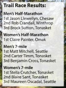
The women’s 7-mile winner, Stella Crutcher of Tonasket, stated, “This was my first trail race, and the course was mentally and physically challenging to say the least. Whether it be the course’s 850-foot climb within the first 1.5 miles, or the mental challenge of completing the race.” The morning mountain run treated runners to cooler temperatures and wildflowers provided a serene backdrop to the challenging course. “The landscape was very beautiful and it encouraged me to keep on running.” Crutcher explained. The men’s half-marathon winner, Jason Llewellyn of Chesaw, spoke highly of the race, stating, “Running the 1st annual Get Lost trail race was an awesome experience,” later adding, “The volunteers from OHA did an amazing job putting this all together. What an awesome organization to be a part of!”