
Tag: buckhorn mine

Issues by Water Year: 2010

After more than three years of operation, ongoing issues continue to ebb and flow, such as some significant water quality challenges on Buckhorn that have corrective action in process.

Water Year 2010 Annual Meeting

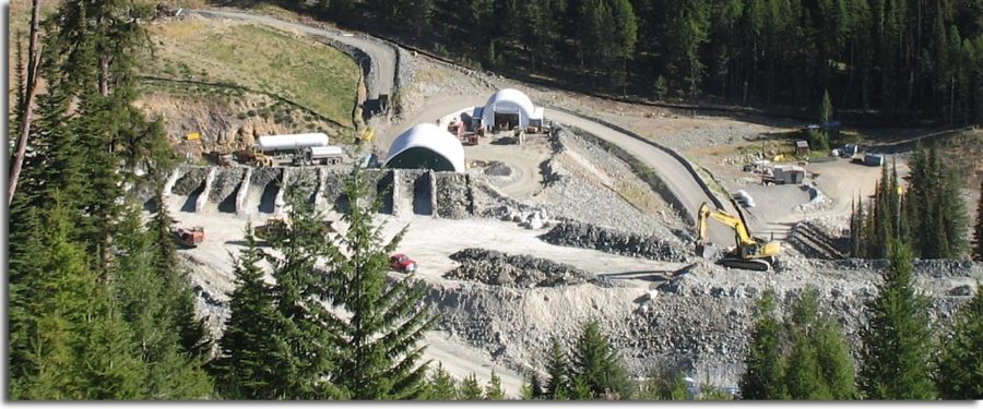
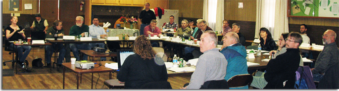
The annual coordination meeting to discuss Buckhorn Mine’s Water Year 2010 data took place at the Eagle Cliff Grange on the bank of the Kettle River on March 15th. Annual monitoring reports were submitted to the agencies a few weeks prior to the meeting. The purpose of the annual meeting is to review a summary of the previous year’s monitoring data, discuss the adequacy of monitoring plans and recommend any modifications that might be needed. OHA opened the meeting with a presentation of our analysis of the monitoring data, and followed up with a presentation and the independent review by Ann Maest of Stratus Consulting, which laid out our concerns regarding the company’s analysis. OHA also raised concern over contaminated mine leakage and offered suggestions to address the issue.

OHA submitted a memorandum outlining changes to the Adaptive Management Plan we recommend and a list of actions that would improve the environmental reporting and performance of the mine. A separate memo was also submitted regarding Kinross/Crown’s failure to apply the required shotcrete to potentially acid generating (PAG) mine walls.

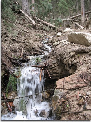
Kinross began their presentation with an overview of how much they contribute to the community with jobs and donations and how much gold has been produced. Next, they provided an overview of the capture zone issue, the water treatment facility and surface and ground water quality. Prior to the annual reporting, Kinross adamantly maintained that the capture zone was effectively intercepting all mine contaminants. At the annual meeting, Kinross consultant, Golder Associates, presented quite another story. After rerunning the groundwater model, it is clear that four monitoring wells in the North Lookout Fault-3, east of the mine, are outside the capture zone and that it could take years for the contamination to dissipate. Mine contamination has also leaked west of Buckhorn into the surface water of South Bolster Creek.

OHA Recommended That…

Operational Changes should be Documented:

Adaptive management will continue to play a critical role in mining operations. In fact, some of the most important operational changes that have taken place over the past year are not included, or are minimally mentioned, in the annual reporting. For instance, the renovation and upgrade of the treatment facility has greatly improved effluent discharge, thereby reducing downstream impacts; however, it is not discussed in any detail in the annual reports.

Unless the changes that have taken place are documented, future mine staff and regulators will only have a tangential understanding of how and why things are done the way they are done. This is an inadequacy of the Adaptive Management Plan (AMP). OHA recommended that a provision be added for annual reporting to include an explanation of the issues the mine has addressed over the year as well as the proposed or implemented solutions. Kinross and the agencies agreed with OHA that annual reporting will now include major changes that have been implemented at the mine, including an explanation of reasons for instituting the changes.

Faults Should be Mapped:

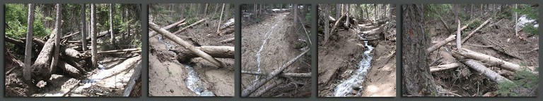
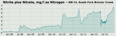
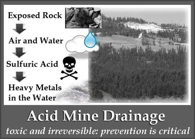
The network of fractures throughout the mine and underlying the facilities are more extensive than previously understood by mine officials. Contamination from the underground mine, and likely the waste rock/ore stockpile, travels underground through interconnected faults, bypassing the dewatering wells and ending up in ground and surface water down-gradient from the mine. The increase in sulfates could indicate the start of acid mine drainage. Nitrates from blasting have increased to the west, south, and east of the mine.

While the 2010 shotcrete inspection report failed to present the required volume and method of shotcrete application, it did reveal that additional faults exist, which have not been noted in any previous documentation. Understanding the location of new faults is well established as a critical factor in understanding the movement of contaminants.

The Development Rock Management Plan (DRMP) provides procedures for identifying PAG rock to secure safe storage and disposal. Part of that process includes mapping the location from which PAG is mined. OHA suggested that the quarterly reporting of development rock characterization should be modified to include quarterly mapping of PAG locations and mapping of any fault and fractures that are identified while mining. These reports would be summarized annually. This modification was accepted.

OHA also recommended that additional investigations of hydrologic pathways and faults on the mine site should be conducted. Studies could include additional pump tests, with response wells located across known or suspected faults; additional geophysical studies; and additional geochemical studies of water quality in mine sources and at stream and groundwater monitoring points. These suggestions are being considered.

Shotcrete is Needed To Prevent Acid Mine Drainage:

One very important aspect of the DRMP and AMP that is known to be highly effective has unfortunately not been implemented. Shotcrete inspection reporting reveals that only limited amounts of shotcrete were applied for PAG pacification last year and none in the previous year. Shotcrete is supposed to be applied to all PAG headings. For the last three years there have been increasing amounts of PAG rock and a corresponding greater amount of PAG headings. The application of shotcrete is not discretionary; it is a provision of the DRMP and AMP to be implemented because it would reduce the likelihood of Acid Mine Drainage (AMD).

The AMP for Development Rock states, “Shotcrete will be used to prevent air and moisture penetrating into blast fractures in the Damaged Rock Zone (DRZ), thus reducing oxidation and interaction between DRZ PAG rock and mine water. This shotcrete will also reduce oxidation (by limiting airflow) of DRZ PAG rock that remains exposed above the water table after the groundwater system has re-equilibrated. As part of the adaptive management plan, the extent of the shotcrete will be determined based on the mine engineer’s mapping of PAG rock, and water flows into the mine.”

Shotcrete creates a reasonably effective barrier to prevent AMD, whereas backfilled cement does not create an effective barrier. Backfilled cement performs a structural function so that additional mining can take place, but does not necessarily form a seal. As a result, water that infiltrates around and through the backfilled cement rock has a high probability of eventually picking up contaminants and spreading the contaminants into the ground and surface water. Unfortunately, for the past two years, little or no shotcrete has been applied. Kinross says that from now on they will apply shotcrete but they still think that no shotcrete is needed if cemented backfill fills the mine-shafts. This is not acceptable.

At the annual coordination meeting, OHA requested that Ecology require Kinross to go back and shotcrete all mine-shafts that contain PAG rock. Some of the shafts have already been filled with cement. OHA has asked that this cement be removed and shotcrete applied as required. The agencies will consider this request. OHA also requested that in the future, no cemented rock fill is placed until the PAG headings are properly sealed (shotcreted). OHA requested that PAG stockpile discharge monitoring occur monthly, a suggestion that will be implemented, as well as more often during spring runoff, which the company is considering.

Adaptive Management Issues

Kettle River Tailings Facility: There is a trend of increasing concentrations of nitrate, sulfate, and TDS in surface water; this should require Adaptive Management Plan action.

Issues by Water Year: 2011

Landslide

In May 2011, a large slope failure below the Buckhorn Mine sent a wall of mud and large trees flowing down Gold Bowl Creek. Just below the mine facilities and one of the treated mine water discharge areas, the side hill of Gold Bowl Creek gave way, sending mud cascading thousands of feet, uprooting large trees and scouring the creek drainage of all vegetation 12-15 feet high. Surface water monitoring site SW-9 was obliterated by the May 14, 2011 landslide. A replacement monitoring point was established at SW-9A.

According to Geology (Chernicoff & Whitney, 2002), blasting that accompanies mining, quarrying, and road construction can trigger mass movement. Vibration from these activities can force apart grains of loose sediment, eliminating the friction between them. Sometimes human activity, such as mining, may combine with natural factors to increase the chance of mass movement.

Crown/Kinross consultant Golder Associates performed a dye test to see if treated mine water discharged to the stormwater ponds DA 10/11 was connected to the massive mudslide that blew out the side hill of Gold Bowl Creek in May 2011, uprooting trees and scouring over half a mile of creek. In summary, the results showed that DA 10 contributed to flows in the slide area. OHA does not consider the DA 11 test conclusive because it occurred after the slide area had dried out. There was no flow by the time of the test. Ecology has curtailed treated mine water discharge to these locations.

The National Pollution Discharge Elimination System (NPDES) states, “Discharges must not cause erosion or slope instability.” Crown/Kinross went to great lengths to represent this spring’s mudslide as unrelated to the mining activity. However, as noted above, a connection was established.

As a result of landslides, two of the four treated water discharge points were restricted, and the company sought additional places to discharge treated mine water. Additional environmental review will be necessary to examine the impacts of discharging large quantities of treated water into yet unidentified locations, before the new discharge points can be permitted. It is in everyone’s best interest for new discharge points to be developed; otherwise, water builds up in the mine.

Water Quality Requirements Violated

  • Concentrations of mine-related contaminants have been increasing in surface water and in groundwater since the mine operations began
  • Water infiltrating through the PAG development rock has leached contaminants into Gold Bowl Creek
  • Erosion from treated mine discharge has contributed to slope instability
  • Other unpermitted mine discharge has entered surface water

The increases in nitrate and chloride concentrations in SW-14 made it apparent that a preferential pathway exists between the mine area and upper South Fork Bolster Creek.

The mine has leaked contaminants since it began operations. The mine’s monitoring shows that the mine has failed to maintain a capture zone, which is supposed to keep mine contaminants out of surrounding ground and surface water. Recent water quality violations began with the spring thaw in May 2011, when a major mudslide erupted below one of the treated mine water discharge locations. The landslide released a 20 foot wall of mud, scouring the vegetation and ripping out trees for half a mile down Gold Bowl Creek.

During May and June, water quality in Gold Bowl Creek exceeded standards for nitrates from blasting and sulfates from acid generating rocks. Sulfide rock removed from the mine is stored on the surface, exposed to the elements and can form sulfuric acid. Nitrates from blasting have also been elevated in Bolster Creek, west of Buckhorn, and in groundwater wells east of the mine.

Unfortunately, discharges of pollutants have been occurring from the mine that are not permitted by the NPDES. In fact, the permit specifically states that no other discharges are permitted. However, contaminants from the mine and waste rock pile discharges have increased in ground and surface water, sometimes in excess of Water Quality Standards (WQS), and yet since April 2008, Ecology has not issued violations for failure to maintain the capture zone, nor for discharges from the waste rock pile. Throughout 2011, OHA continued to encourage Ecology to hold the company accountable for these non-permitted discharges.

Reporting Issues

As part of the response to the Department of Ecology’s Administrative Order #8820, Crown/Kinross updated the Groundwater flow model for the Buckhorn Mine. OHA reviewed the Nov. 2011 Golder report entitled, “Updated Groundwater Flow Model and Mine Inflow Estimates,” and provided comments to Ecology. OHA found the report to be lacking coverage of some critical issues, including omission of grouting to minimize groundwater inflow to the mine and a lack of numeric estimates of groundwater inflow to the mine.

Development Rock Reporting Needs Improvement

Water leaching through development (waste) rock piles, especially in the spring, has increased pollutants in ground and surface water. Kinross is required to submit a report to the Department of Ecology each quarter to provide an analysis of the past quarter’s development rock information.

Ecology rejected the 1st quarter report submitted in August and is requiring the company to generate a report based on criteria at that time.

Crown/Kinross made commitments at the March 15, 2011 Annual Meeting regarding reporting of development rock, including mapping faults and applying shotcrete. No information about faults was in the quarterly report, and shotcrete application was limited.

Contaminants travel through faults or other preferential pathways in the underground mine. Faults and voids in the cemented rock fill (CRF) are identified during mining. OHA had asked that these features be identified in the quarterly reporting to help track contaminant transport. OHA also suggested that increased shotcreting would increase groundwater protection. This suggestion comes as a result of failure of the capture zone, uncertainty related to seasonal fluctuations, and the unreliability of the groundwater flow model. OHA is concerned that the large backlog of PAG DRZ in the underground mine and the failures of the capture zone are degrading water quality around the mine.

Cells where rock from the mine is placed for testing to determine if it is ore or waste rock, and if it is PAG.

OHA also recommended that ore headings should be analyzed for acid generating potential and if it is determined to be PAG, the area should be shotcreted before CRF is applied for ground control. Until this point, it appears that ore has not been tested to determine whether it is potentially acid generating (PAG)!

NPDES Permit Up for Renewal

In the midst of these serious issues, the National Pollution Discharge Elimination System (NPDES) permit came up for renewal. An administrative extension was granted. OHA maintained that at the very least, the NPDES renewal should increase reporting during the spring freshet so that discharges from the waste rock can be more thoroughly monitored. In 2011, one downstream well was monitored once a month, which is insufficient both in frequency and scope to ensure that water quality changes during freshet would be noticed. OHA also strongly suggested that any increase in contaminants beyond the background baseline levels should be highlighted and watched for increasing trends, and all water quality violations should be noted.

Issues by Water Year: 2012

2012 brought official recognition of the Water Quality permit violations, which were swiftly appealed by the company.

Buckhorn Mine Violates Water Quality Permit

On July 16, 2012, the Buckhorn Mine was fined $395,000 for water quality violations.

The largest part of Ecology’s July 2012 penalty was issued for failing to capture and treat mine contaminants for 94 days, thereby violating the NPDES permit. According to OHA’s analysis, the capture zone has been violated since July 2008, for a total of more than 1,640 days.

If a capture zone is not maintained, mine water can enter the groundwater system without treatment. Changes in water quality in stations downgradient of the mine indicate that the hydraulic containment system provided by the mine (capture zone) is not fully effective in containing mine water. Water quality monitoring data for South Fork Bolster Creek station SW-14 shows elevated concentrations of nitrite plus nitrate above background values in every sample collected since July 2008, which demonstrates that Crown has failed to maintain a capture zone on the west side of Buckhorn Mountain. The NPDES strictly forbids any discharges other than those that are permitted and there is no permit to discharge pollutants into Bolster Creek.

Nitrates (Nitrite plus Nitrate, mg/l as Nitrogen) at the SW-14 monitoring point in the South Fork of Bolster Creek are significantly above baseline, indicating escape of contaminants outside the capture zone.

Crown Denies Responsibility for Water Problems

The mining company appealed Ecology’s July 2012 penalty for permit violations at the Buckhorn Mine, denying responsibility for causing the Gold Bowl landslide and for failure of the mine’s capture zone. Crown challenged the amount of the penalties as too high.

Despite the thorough documentation of slope stability problems below treated water discharge locations, and water quality problems below the waste rock piles, the company denied responsibility.

The Buckhorn Mine Adaptive Management Plan (AMP) for Water Quality Changes Due to Mining clearly states, “Mitigation elements incorporated into the Buckhorn Mt. Project to protect surface water and groundwater quality include: Containment of mine water within the mine as a result of the capture zone that develops surrounding the underground mine and dewatering wells.”

There is not an exception written into the language of the mine plans allowing for some of the contaminants to escape the capture zone. All contaminated water emanating from the mine should be captured. The monitoring program laid out in the AMP clearly aims “to determine… whether the mine and dewatering wells are creating a capture zone to contain seepage from the mine, development rock and ore stockpiles.” The plan does not call for partial containment of seepage. Based on the AMP, OHA has an expectation that Crown Resources will maintain a separation between contaminants generated from the Buckhorn Mine and the environment; however, contaminants are emanating beyond the footprint of the mine.

Gold Bowl Creek cuts through sediment deposited by landslide, after the May 2011 slide below the mine.

The appeals have since been settled.

2012 In Review – OHA Issues with the Buckhorn Mine

In 2012, OHA’s issues and concerns prompted numerous memos and letters to Crown/Kinross and regulatory agencies. OHA started the year in early January with a memo to Ecology, commenting on Crown’s consultant’s Updated Groundwater Model (Nov. 2011) and Crown’s response to Administrative Order 8820. After a thorough review of the details, OHA concluded that the report does not demonstrate that the revised groundwater flow model is calibrated to site conditions, nor is it capable of simulating mine conditions (such as leakage of mine-related contaminants to area streams). The revised model failed to simulate the effects of high precipitation and recharge in 2011, and the report has not adequately demonstrated that there is an effective capture zone around the mine. A revised report should be prepared that more directly addresses the success of model calibration and how shortcomings of the model can be improved.

OHA wrote letters to and met with Crown, explained our problems with their proposal to discharge treated mine water into Gold Creek, and provided suggestions of analysis that should be done for last year’s annual review. Crown’s response was that if OHA wants this work to be done, we should do it ourselves.

In February 2012, OHA prepared a memo showing that Crown has failed to maintain the capture zone, in violation of the waste discharge permit.

A year ago in March, OHA presented a memo to all the participants of the mine’s annual review meeting, with recommendations of modifications to the Adaptive Management Plan (AMP), based on concerns that the reporting ignores relevant information and fails to provide thoughtful analysis of conditions at the mine. Some of the main points of the memo are:

  1. The Shotcrete Evaluation is incomplete, lacks objectivity, and for consecutive years has failed to include basic DRMP (Development Rock Management Plan) and AMP requirements. OHA recommends that the 2011 shotcrete evaluation be rejected and that an independent third party submit a new evaluation.
  2. Discharge from the PAG stockpile should be monitored and reported for volume/flow and water quality monthly, with the exception of during spring runoff, when it should be monitored daily.
  3. Additional piezometers and monitoring wells should be installed to reliably establish the extent of the capture zone.
  4. An analysis of ground water elevations, precipitation and dewatering rates should be conducted to better predict the need for water treatment and underground storage.
  5. A new evaluation of geochemical predictions, influent quality and outflow quality should be conducted.

In April 2012, OHA provided Ecology with a synopsis of the shotcrete requirements, including recommendations for enforcement. Shotcrete is a fine-grained cement that helps provide a barrier between reactive rock and preferential pathways to groundwater. Many of the requirements have either been ignored or only partially implemented by Crown.

In June 2012, OHA presented numerous memos to Ecology, beginning with input on Crown’s application for NPDES permit renewal, to supplement the discussions and to increase protection of the environment. OHA raised concerns about the Adaptive Management Plan (AMP) being outdated; a new AMP should be created to reflect what has been and is being learned from the actual data, as well as the operational changes that have been or should be made. Ecology requested we present a memo on the subject, the main points of which are outlined below:

  1. Annual reporting of operational changes should be required, including an explanation of each issue that has been addressed and the changes that have been proposed or implemented. Without a record of these changes, implementation of adaptive management cannot be effectively evaluated.
  2. Seeps and Springs: The 2007 AMP addresses impacts of dewatering on the Nine Acre Wetland. Operational changes designed to avoid further landslides have reduced or eliminated two effluent discharge points, leaving most effluent from the mine to be discharged into the Nine Acre Wetland. This AMP should be revised to reflect the current situation.
  3. Mine Dewatering and water supply impacts to streamflow: To provide mitigation of dewatering impacts, this AMP requires monitoring to determine whether the infiltration gallery is functioning properly, where water is returned to the soil. It appears that the “gradual increase of discharge” to the gallery was not adhered to, and in the absence of performance evaluation, its functions were compromised. This objective should be updated.
  4. Water Quality Changes Due to Mining Operations: Various adaptive management strategies have been adopted to mitigate water quality changes at the mine. The AMP should be updated to reflect the current situation, including increased analysis of data, action levels and mitigation strategies. Adaptive management for failure of the capture zone should be considered, including additional monitoring, analysis and remedial actions.
  5. Development Rock Management: The AMP should be updated to reflect the current situation, including increased analysis of data, action levels and mitigation strategies. These updates should consider actual water quality conditions, implementation of shotcrete requirements, and realistic assessment of discharges from PAG stockpiles.
  6. Slope Stability: Current monitoring and adaptive management of slope stability is ineffectual. If there is any doubt regarding this statement, the current monitoring plan should be evaluated in light of the 2011 landslide. The new AMP should provide for evaluation and management of slope stability.

Also in June 2012, OHA provided Ecology with a memo regarding Crown’s mischaracterization of the 002 treated mine water discharge location.

In October 2012, OHA commended Ecology’s regional director for issuing the penalty to Crown for violating their permit and provided additional examples of provisions that have been violated, including failure to notify Ecology when monitoring values exceeded background values.

How Gold Mining Can Affect Water Quality

There are several ways in which gold mining can affect water quality. Some of the following information is taken from the Safe Drinking Water Foundation online article, “Mining and Water Pollution.” Local photos are displayed, pertaining to Buckhorn Mountain and the associated facilities.

Introduction

A stream feeding the Nine Acre Wetland, located near the Buckhorn mining operation

Water is essential to life on our planet. A prerequisite of sustainable development must be to ensure uncontaminated streams, rivers, lakes and oceans.

Mining affects fresh water through heavy use of water in processing ore, and through water pollution from discharged mine effluent and seepage from tailings and waste rock impoundments. Increasingly, human activities such as mining threaten the water sources on which we all depend. Water has been called “mining’s most common casualty” (James Lyon, interview, Mineral Policy Center, Washington DC). There is growing awareness of the environmental legacy of mining activities that have been undertaken with little concern for the environment. The price we have paid for our everyday use of minerals has sometimes been very high. Mining by its nature consumes, diverts and can seriously pollute water resources.

Negative Impacts

While there have been improvements to mining practices in recent years, significant environmental risks remain. Negative impacts can vary from the sedimentation caused by poorly built roads during exploration through to the sediment, and disturbance of water during mine construction. Water pollution from mine waste rock and tailings may need to be managed for decades, if not centuries, after closure. These impacts depend on a variety of factors, such as the sensitivity of local terrain, the composition of minerals being mined, the type of technology employed, the skill, knowledge and environmental commitment of the company, and finally, our ability to monitor and enforce compliance with environmental regulations. One of the problems is that mining has become more mechanized and therefore able to handle more rock and ore material than ever before. Therefore, mine waste has multiplied enormously. As mine technologies are developed to make it more profitable to mine low grade ore, even more waste will be generated in the future.

Waste from the Mining Process

Ore is mineralized rock containing a valued metal such as gold…The ore is crushed into finely ground tailings for processing with various chemicals and separating processes to extract the final product.

Kettle River facilities

Types of Water Pollution from Mining

  • Acid Mine Drainage
    • Many of the metals being mined in North America, including the gold mined from Buckhorn, tend to be found in rock that contains sulfide minerals. When ore and surrounding rock are excavated during mining, the sulfides become exposed to water and air, and may form sulfuric acid. This acid in turn leaches metals and other substances from the rocks that can harm ecosystems. The acid will leach from the rock as long as its source rock is exposed to air and water and until the sulphides are leached out – a process that can last hundreds, even thousands of years. Acid is carried off the minesite by rainwater or surface drainage and deposited into nearby streams, rivers, lakes and groundwater. Acid mine drainage is considered one of the most serious environmental threats posed by mining, and it can devastate aquatic resources for generations.
  • Heavy Metal Contamination & Leaching
    • Heavy metal pollution is caused when such metals as arsenic, cobalt, copper, cadmium, lead, silver and zinc contained in excavated rock or exposed in an underground mine come in contact with water. Metals are leached out and carried downstream as water washes over the rock surface. Although metals can become mobile in neutral pH conditions, leaching is particularly accelerated in the low pH conditions such as are created by Acid Mine Drainage.
  • Processing Chemicals Pollution
    • This kind of pollution occurs when chemical agents (such as cyanide or sulphuric acid used by mining companies to separate the target mineral from the ore) spill, leak, or leach from the mine site into nearby water bodies. These chemicals can be highly toxic to humans and wildlife.
  • Erosion and Sedimentation
    • Mineral development disturbs soil and rock in the course of constructing and maintaining roads, open pits, and waste impoundments. In the absence of adequate prevention and control strategies, erosion of the exposed earth may carry substantial amounts of sediment into streams, rivers and lakes. Excessive sediment can clog riverbeds and smother watershed vegetation, wildlife habitat and aquatic organisms.
Drillpad exploration

Water Quantity

Mining can deplete surface and groundwater supplies. Groundwater withdrawals may damage or destroy streamside habitat many miles from the actual mine site. [end quote from the Mining and Water Pollution article]

Surface Remediation Well Underway, Fall 2018

Kinross began removing construction fill from the surface of the mine site and putting it underground even before they finished mining, but that has not reduced the pollution problem. Once mining was complete in 2017, Kinross rapidly began moving the rest of the construction fill into the underground mine shafts; even the fill that was under the treatment facility was moved. To do this, they dismantled the facility without authorization, leaving the mine site without a working treatment facility for a period of six months.

At this point, most of the buildings have been removed and the ground surface has been recontoured and seeded. On the surface, things are looking more natural. However, downgradient wells are still high in sulfates and other contaminants.

Waste Rock

Agency Documents

The public can access permit documents such as permits, fact sheets, and public notices through PARIS (the Permit and Reporting Information System). 

Buckhorn Mine Related Documents

Documents, including water right decisions, can be requested from Ecology

Continue reading

  • 1
  • 2
Go Back