3D Visualization, Pacific Groundwater Group
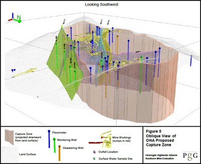
Pacific Groundwater Group created a 3D visualization video for OHA as part of and in support of OHA’s comments on the draft NPDES Permit renewal in 2013. It begins with a visualization of the Buckhorn Mine underground workings with relevant faults and monitoring wells. It transitions to show: first the 2006 FSEIS capture zone, then the expansion of the capture zone proposed in the Draft NPDES, and then OHA’s proposed capture zone as seen from the south looking north. OHA’s proposed capture zone consists of the Draft NPDES depiction in the north, south and west and with the 2006 FSEIS depicted on the east side. The visualization then transitions to a view looking southwest from northeast of Buckhorn Mountain, and repeats display of the same sequence of capture zones.
About the Project:
Visualizing how groundwater in Buckhorn Mountain interacts with the mine, geologic faults, and dewatering wells is coming closer to reality with OHA’s 3D Visualization Project, which will increase everyone’s understanding of how water moves underground. At this point, we have created a number of animations circling a transparent depiction of Buckhorn Mountain. The color-coded animations include various dewatering and monitoring wells and piezometers in cross sections of interest, with see-through portrayal of the company’s projected faults and underground mine workings. The groundwater levels at key seasons will be added to assist in an analysis of how the dewatering wells are influencing groundwater flow.
Over the years of the mine, OHA has made numerous recommendations to the company that they analyze the actual groundwater monitoring data instead of relying on predictive models, which have not been effective at predicting actual conditions. Early in 2013, OHA initiated a 3D mapping project, which developed into the 3D visualization. OHA is hopeful that this will give everyone another tool to analyze the monitoring data and hopefully see where the gaps are in understanding groundwater flow paths. The end goal is to stop contaminants from escaping the mine.